I needed to get the cub to Baker, Montana so that Roger could take it under his wing and address the modifications that would allow us to make the trip out to Montana and Washington state later this fall. And perhaps a flight to Alaska next year. For those of you who are following this saga, the trip to Alaska planned for this year will still be made, but will be done in a commercial aircraft. Not optimal, but who can complain? I still get to spend 3 weeks in a Talkeetna cabin with my wife and son, and fish the early King salmon run.
But to the current situation... The weather looked pretty good. Who could imagine a high pressure system sitting over the Great Plains and large enough to extend into the Great Lakes region? Even more favorable, it was situated such that I was located on the lower portion of it, and would catch favorable easterly winds for almost the entire 900 mile, 8-10 hour trip. Somewhere in the presentation of this weather briefing, there was a catch. I couldn't figure out where it was, but I wasn't going to hesitate.

Thursday evening I went out to the hangar to fuel the plane and give it a careful preflight. The tent, winter sleeping bag, survival kit, and food were all packed. I was pretty sure that I would end up spending at least one night camped out in some grass strip airport in western Iowa or South Dakota. My destination was Baker, Montana, and it's location just west of the North Dakota/Montana state line always portends wind, precipitation, and cold temps. It's best to be prepared to put down the aircraft in case of non-VFR conditions.
At dawn of the next day, Friday, I returned to the hangar and packed the last minute food that Tricia had prepared. If I were to get caught in a tent for a day or two, I would need to have a book and some good cookies. Thus she had prepared some of her calorie rich chocolate chip/coconut/oatmeal cookies the night before. They provide all the nutrients one might need for any meal, including breakfast. They're actualy survival cookies. So I had a couple for breakfast as I rolled the cub out for departure...
The weather was high broken overcast, 60 degress, and easterly wind of about 10 knots. So I got into the cockpit, rearranged all the water bottles, sandwiches, cookies, charts, gloves, and cameras, then finally began to taxi. The sun was just coming up over the horizon, and my taxi direction was easterly. No one was on the field and no one had yet arrived at the FBO. So I simply departed from the taxiway. I only needed about 100 feet and was thus on my way west to Montana.
The weather briefer I had spoken to earlier had cautioned me about some rain showers along the route thru southern Wisconsin and into Iowa. I could see the showers easily on the NexRad weather uplink on the Garmin 496. Flying an aircraft with current weather in the cockpit is a little like playing a video game in real time. So I looped the weather radar in order to see where the rain was heading, and choose a course slightly north of my GPS-direct course in order to avoid it. This was going to be a flight to enjoy the scenery. I needed to fly VFR since I was not equipped to fly instrument conditions in the cub. There was no need to fly high, so I choose an altitute of 500 feet AGL. This allowed good clearance of the power lines and radio towers, and I could see and wave to the folks mowing their lawns in the early morn.

Leaving Indiana, I then had to negotiate the class C and class B controlled airspace around Chicago. Otherwise my GPS-direct course would have taken me directly over O'Hare. So I flew towards the west at 1500 feet, and ducked under Midway's airspace and the inner tier of O'Hare's airspace. I cleared with Dupage class D, and then headed due north to avoid the center of the rainstorms located in Wisconsin.

I didn't bother talking to Center because they couldn't tell me anything I didn't know already. No commercial traffic was flying as low as I was, and I had more updated weather information than they had. So I just listened on their frequency as they routinely reported to the other traffic: "an unidentified, slow moving aircraft moving in a west, northwesterly direction." They were describing me this early Friday morning: unidentified, slow moving, and heading west and north. Could life possibly be better?
Wisconsin began it's usual litany of slow rolling hills. It is usually difficult to recognize that the ground is beginning to take on a rolling topography, but southern Wisconsin is rural. The contour planting of the rolling landscape gives a 3 dimensionality to the aerial view that is similar to looking at a USFS topographic map. Wisconsin also has a great number of rocky cliffs that can only be seen if you are flying close to the ground. It was a peaceful beautiful morning as I cruised over the Wisconsin River and towards the Mississippi. The rivers were all flooded and there was sparse tug traffic as I flew over the waterways. It was time for more chocolate chip breakfast cookies to mark the occasion.

Iowa continued with rolling farm fields, except for one impressive change. There were now a large number of windmills on the plains. I would see acres of windmills as I crossed the state. They were tall, and I would have to climb slightly in order to give them clearance. At least they were easily seen and avoided, unlike the tall radio towers that usually had guy wires coming off them for support. (I have nightmares about avoiding a collision with a radio tower, only to find myself colliding with one of the support wires that extends out a ridiculous distance from the tower bases.)
The amusing thing about the wind mills was that they all were facing in my direction. From an aviator's standpoint that means that they must be facing into the wind and thus I must have the wind to my tail. And this turned out to be the case. I indeed had a 10-17 knot tailwind during my entire flight west. As all aviators know, that is generally never the case. The prevailing winds are always westerly. I was reaping the benefits of traveling in the lower portion of the clockwise high pressure system that was centered over the Great Plains. I was blessed.

I noted the little dirt road that demarcated the border between Iowa and South Dakota. It was a fairly barren area and there were several farms that seemed to span both sides of the road. I wondered which state they claimed as their residence. Were there tax or ownership advantages to choosing one state over the other? The cows certainly didn't seem to care. There were plenty of them, and they contentedly continued to graze the fields, hills and watersheds in the now-noon-day overcast that was building.
I was flying uphill. Aviators will understand what I am referring to. Field elevation at Valparaiso, located at the southern tip of Lake Michigan, is 780 feet. As one proceeds west and north the elevation becomes greater. When I stopped for fuel in western Iowa, the elevation was 1700 feet. Ultimately I would land at Baker, Montana, and the elevation would be 3000 feet.
Thus I played with the recurrent ridiculous concept that if I stayed at Valparaiso's pattern altitude for my entire trip (1000 feet above ground level) , then I could land in western Iowa without ever changing my altitude. Or I could impact the ground somewhere in Iowa and continue to Baker underground, only to find that I would have to climb 1200 feet out of a hole to be at ground level in Montana. Ridiculous. But that's what happens on an 8 hour flight like this. Time for another breakfast cookie or two...
South Dakota was fairly boring. And my bottom was getting tired of sitting, as well. So nothing was quite as entertaining as when I started. The weather was beginning to get interesting however. The ceiling had begun to lower and now had become a solid overcast varying between 300 and 1000 feet above ground level. I had been looking out my skylight and had noticed that the cloud ceiling was coming down. I had tracked the AWOS reports at airports along the way, and the rocordings had confirmed the lowering trend as well. By early afternoon Baker, Montana was still reporting 200-300 foot overcast ceilings and consequent IFR conditions. It looked like my thoughts about camping out in South Dakota for the night just might become a reality. My survival cookies were beginning to run low, however, so I was feeling the pressure to persevere.

About mid South Dakota I found stable VFR conditions at about 500 AGL. Visibility was definitely acceptable at 10 miles or greater at that altitude. There was no convective activity, although the winds were picking up and there was mild turbulence. No complaints from me however, because the winds continued easterly in their direction. For my last 200 miles, they were 15-20 knots on my tail. Baker-ho! No camping for me this night. I'm looking forward to a wild night in the cow-town of Baker. Let the predicted snow come. I'll be tucked into a bed that is warm and safe, instead of laying in my tent while the freezing rain passes through the area.
Eventually I spied the strange little mountainous hillocks that define the unusual terrain of eastern Montana. They are strange flat tables of rock that are several hundred feet in elevation and usually have radio towers on them. I could easily land a cub on their flat summits, except for the danger of these ubiquitous man-made obstructions. And it seems it's always raining or snowing when I fly over this region. Last time it was snowing with ceilings of 600 feet. This time it was light rain with ceilings of 500 feet. The next morning forcast was for rain/snow with ceilings of 800 feet.
This is cow and oil country, though. It's a little wild west in its character. The town is small, and is defined by "the 4-way" as the local folks refer to it. All directions are give relative to the 4-way stop in the center of town. What I didn't know was that there was a second 4-way stop just north of town, and that confused me for awhile. But eventually I figured that out too, and located the Corner Tavern where I had a beer and burger for dinner.
I like Baker, Montana. It's what I would call an "honest" town. There are no pretenses here. I like the people, and I respect the hard work that it takes to earn a living here. When I met the girl who rented me a room at the Montana Hotel, she greeted me with a big smile and introduced herself as Lori. "My husband and I went to the big city for awhile, but didn't like the lifestyle. We came back here and opened this motel. We put up with the weather and the rattlesnakes."
They advertise wireless internet service, but I told her I could not use it since I had not brought my computer. No problem. She said I could use hers in the front office anytime I wanted. And then I got a couple vouchers for free drinks at the local bar should I decide to eat dinner there. So there I was. Computer access, free drinks with dinner, hot shower and a king bed, good folks, and in Montana. I ask you. Could life be better?

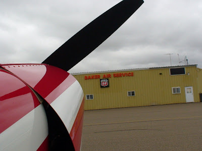
Roger Meggers is the proprieter of Baker Air Service. He and his son Darren run the business which includes the airport FBO, pipeline aerial surveillance, and supercub repair and rebuild facilies. This latter business is what beckoned me to make this trip. Roger built my current supercub and finished it in 2001. I still have difficulty calling it "my" supercub. It was a project aircraft that he built meticulously over several cold Montana winters. His artistry and technical signature is embodied in that aircraft. The only thing that I added to the aircraft was a change of N-number to N530AK. This number represents the birthdate of my son (May 30) when he was born in Alaska (AK). Thus I was able to simultaneously personalize the aircraft and memorialize all our Alaskan adventures.
The aircraft was brought to Baker for the purpose of preparing the plane for travels later this fall and for next year. As indicated earlier, we will forfeit the pleasure of flying our own aircraft to Alaska this year, but will still make that trip aboard United Airlines. Later this fall, after the cub has been equipped with a variable pitch MT prop, 31 inch tundra tires and possibly a cargo pod, we will be set up for a trial run into the backcountry of Idaho, Montana, and Washington state. Tricia and I (with an ample supply of survival cookies) will take that trip as a shakedown for Alaska in 2009. Anyway, that is the plan.
Do plans change? Sometimes they do. But if you keep your nose pointed north and west, and if you are fortunate to have a wife of adventurous spirit, then your dreams just might come true. Throw in a Meggars supercub and survival cookies, and you might just find that the world has become a little smaller, the horizon a little more beckoning, and life a little more adventuous.
Especially at 500 feet AGL.


